
Montauk Lighthouse: A Complete Guide to the Historic Beacon, Striped Bass Blitz, and Fisherman's Paradise
What It Feels Like at the Edge of the Coast
Montauk begins with exposure. There’s no protection from the elements here—wind comes straight off the Atlantic, waves hit the shoreline with force, and the horizon stays completely open. Before the light even develops, the place already feels active.
The lighthouse gives the scene a fixed point, but everything around it is moving. Water, birds, bait, clouds—nothing holds still for long. You’re not looking at a static landscape. You’re standing inside a system that’s constantly reorganizing itself.
Some mornings feel quiet—just low swell, soft light, and long shadows across the beach. Other days build fast. Wind picks up, waves stack, birds gather, and suddenly the entire shoreline is working at once.
That’s what makes Montauk different. It’s not just something you photograph—it’s something you read. The better you understand how the ocean is moving, how the light is shifting, and how the shoreline is reacting, the stronger your position becomes before you even raise the camera.
Explore This Montauk Field Guide
Coastal System — How Montauk Point Is Built
Montauk works because of exposure. At the eastern end of Long Island, the land narrows into a final point and gives itself directly to the Atlantic. There is very little softness in that transition. Rock, surf, wind, and current all meet in a compressed space, which is why the place feels active even when it looks still.
The shoreline structure matters. Bluffs, stone, beach, and broken rock each interact with water differently, and those changes shape where waves build, where birds gather, and where fishermen position themselves. The lighthouse stands above it all, but the real system is below it—where the ocean reorganizes the edge of the land over and over again.
Current is part of the landscape here just as much as rock is. Moving water creates pressure points, seams, and feeding zones, which is why Montauk has such a strong identity not only for photography but for migration, surfcasting, and marine life. You’re not just looking at scenery. You’re looking at a place where movement concentrates.
That openness also changes how the horizon behaves. Some days it feels clean and distant, giving the point a broad, architectural clarity. Other days haze, swell, or cloud compress the space and bring everything closer together. The structure stays the same, but the way you read it shifts constantly.
Once you understand Montauk as a coastal system instead of just a landmark, the rest begins to make sense. Light, season, fishing activity, bird movement, and field positioning all build from this same foundation: exposed land at the meeting point of tide, weather, and the open sea.
Light Behavior — How Montauk Actually Changes
Light at Montauk is faster than most places. There’s nothing blocking it—no mountains, no inland structure—so it moves clean across open water and hits the coastline with full intensity. That’s why the scene can shift from soft to harsh, from flat to dimensional, in a matter of minutes.
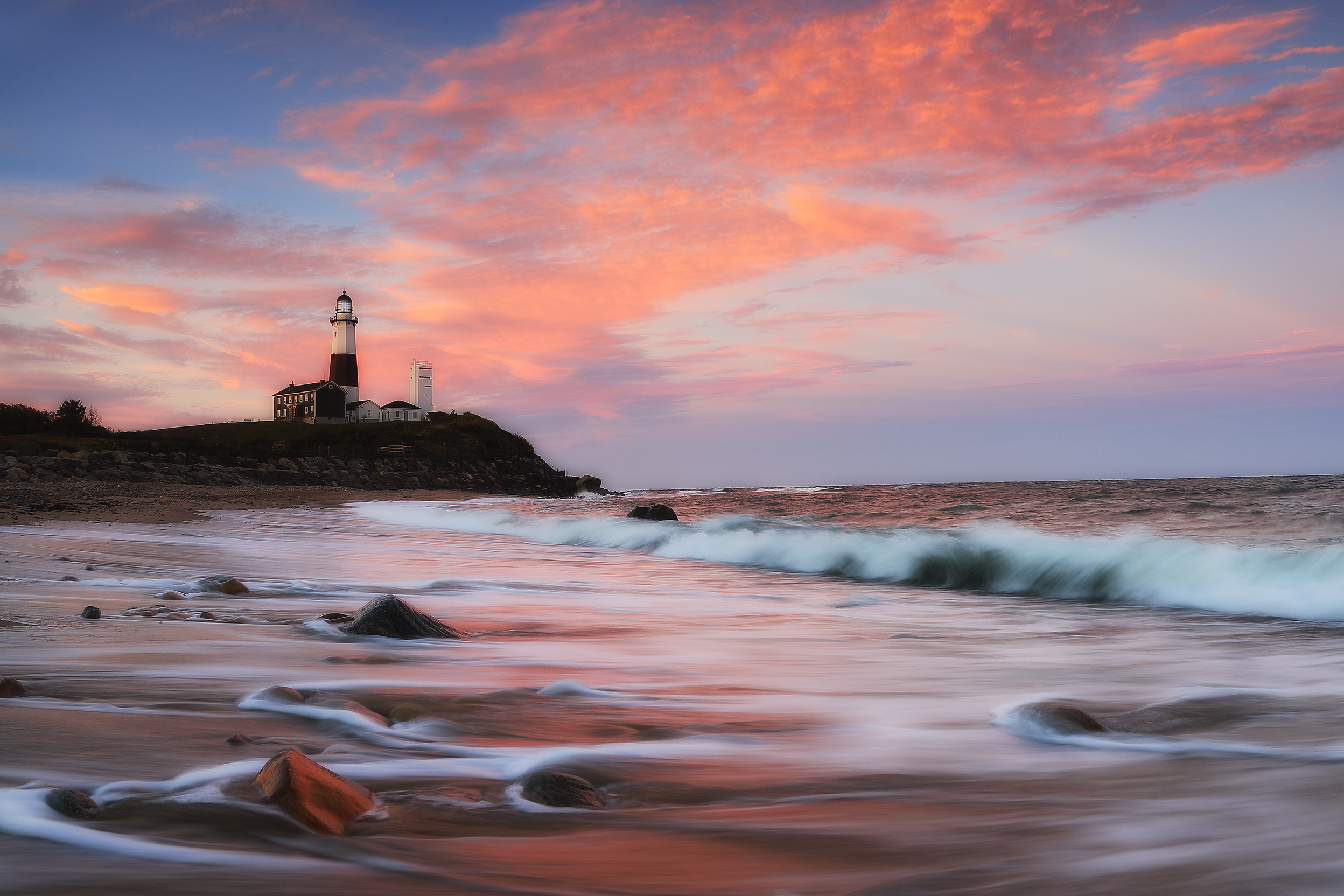
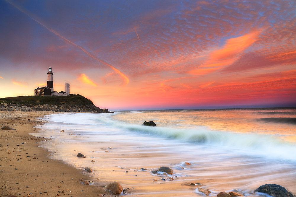
At sunrise, light comes in low across the Atlantic and spreads across the surface before it reaches land. The water often holds color first, then the shoreline begins to separate. Wet sand, foam, and rock edges start reflecting, and the lighthouse moves from silhouette into structure.
Midday light is more direct and less forgiving. It reveals texture—waves, spray, rock detail—but can flatten depth if the sky is empty. This is where weather becomes important. Cloud cover, haze, or moving systems can reintroduce contrast and shape when the sun alone cannot.
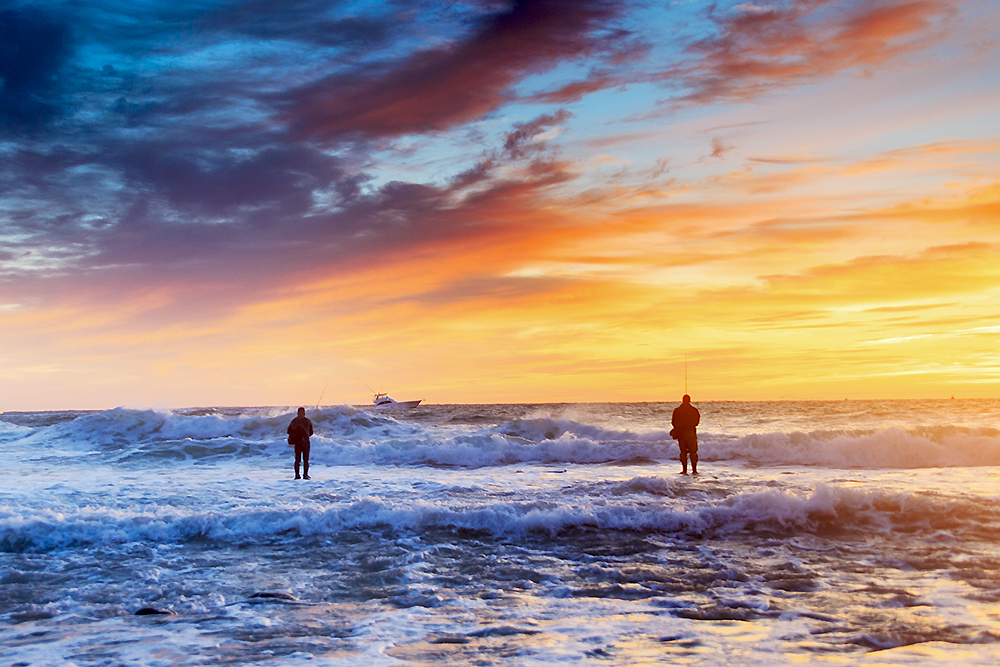
Sunset behaves differently. Instead of moving inland, light drops behind the coastline, often turning the lighthouse into a silhouette while the water carries the remaining color. Reflections strengthen, and the entire scene becomes more about tone than detail.
The most important thing to understand is that Montauk rarely peaks at a single moment. The strongest conditions often happen in transition—when light is changing direction, when clouds break unevenly, or when water and sky briefly align. If you’re only watching the sun, you’re missing how the whole system is reacting.
Seasonal Timing — When Montauk Behaves Differently
Montauk changes more dramatically with season than most coastal locations because it sits directly in the path of migration, shifting currents, and Atlantic weather systems. What you see here in July is not the same place you’ll experience in October.
Summer stretches the light. Long days, warmer water, and calmer conditions open the coastline visually, but the system feels slower and more spread out. You gain time, but often lose the compression and energy that define Montauk at its best.
Fall is the defining season. As water temperatures shift, the striped bass migration pushes through this point, and everything tightens—bait, birds, fish, and fishermen all concentrating along the same edge. This is when Montauk feels fully alive, not just visually but behaviorally.
Winter strips the scene down. Fewer people, harsher wind, cleaner structure. The lighthouse, shoreline, and ocean reduce to their most essential forms. Light stays low and directional, but conditions demand more awareness and preparation.
Spring rebuilds the system. Movement begins again—currents shift, birds return, and the coastline starts to feel active without the full intensity of fall. It’s less predictable, but often more atmospheric.
If you want to work Montauk at a higher level, think in terms of timing, not just season. Match light angle, tide, wind direction, and migration patterns together. Tools like the Seasonal Wildlife Calendar, Nature’s Seasons, and Golden Hour Planner help turn Montauk from a location into a system you can read.
Locations & Field Strategy — How to Position at Montauk Point
Montauk is not one spot—it’s a series of positions along an exposed edge. Where you stand determines what part of the system you see: lighthouse structure, wave energy, fishing activity, or open horizon.
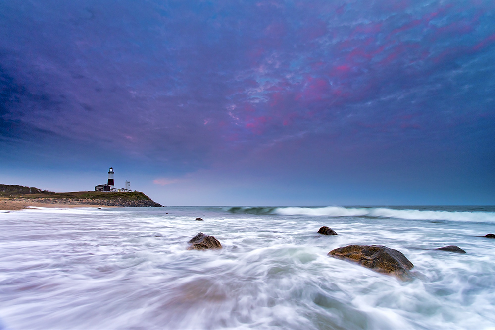
The lighthouse point is the most direct position. From here, you get the cleanest relationship between structure and ocean—waves, rock, and sky all aligned. It’s the most recognizable composition, but also the most crowded and often the least flexible.
Moving down the beach changes the entire scene. The lighthouse becomes a background element instead of the subject, and the coastline opens into longer compositions. This is where you can work with wave patterns, reflections, and scale rather than just the landmark.
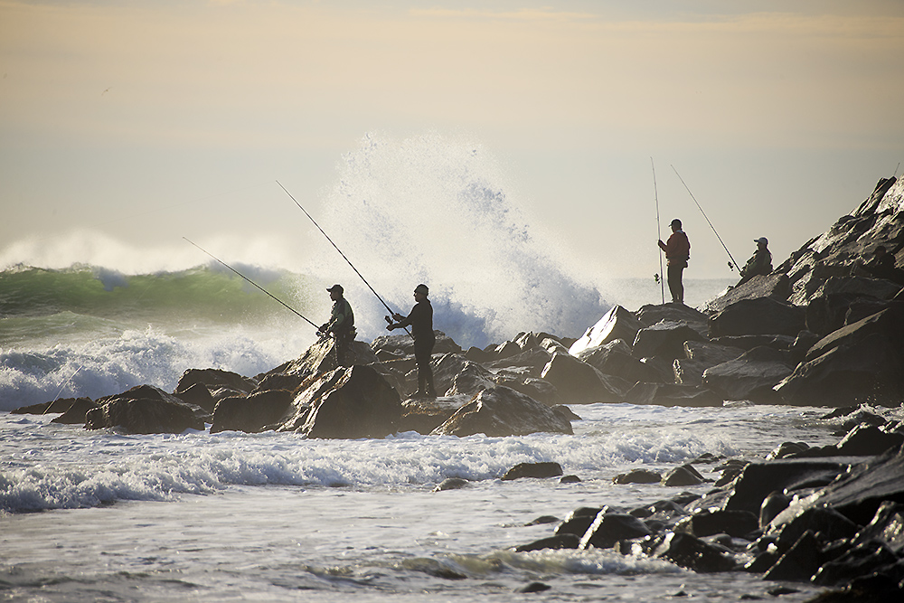
The rocky edges and jetty areas introduce a different dynamic. These are the pressure zones—where waves hit harder, current shifts, and fishermen position during the blitz. Composition here is less about symmetry and more about timing and awareness.
Elevated positions along the bluffs allow you to step back and read the system as a whole. From above, you can see movement—birds working, water breaking, lines forming along the shoreline. It’s one of the best ways to understand what’s happening before choosing where to move next.
Use the map below to understand how these zones connect. It’s not just navigation—it’s how you position yourself relative to light, water movement, and activity along the coast.
Can’t see the map? Open it directly: Montauk Point Photo Map .
Planning & Field Ethics — How to Work Montauk
Montauk rewards awareness more than effort. Conditions change quickly, and the coastline demands attention—both for safety and for understanding what the system is doing in real time.
Start with timing. Early morning and late afternoon give you better light, fewer people, and more space to move. During the fall season, activity builds fast, so arriving early allows you to read the water and position before everything compresses along the shoreline.
Safety is not optional here. Waves can break unpredictably along rock and shoreline edges, especially during wind or storm conditions. Always keep distance from active surf zones and stay aware of changing tide and swell.
Respect the environment and the people working it. Montauk is not just a landscape—it’s an active fishing coastline. Give space to anglers, avoid stepping into active lines or casting zones, and move with awareness of others sharing the shoreline.
Conditions are part of the experience. Wind, fog, and rough water are not problems—they are signals. Instead of waiting for “perfect” weather, learn to work with what the coast is doing. That’s when Montauk becomes most dynamic.
To refine your approach further, explore Wildlife Observation & Field Techniques and your Field Tools. The way you move through Montauk applies to every exposed coastline you work.
Naturepedia Connection — Montauk as an Ocean Edge System
Montauk is best understood as a convergence point. Ocean current, seasonal migration, wind, tide, and light all compress into one exposed edge of land. What looks like a simple lighthouse location is actually a highly active system where energy, movement, and behavior concentrate.
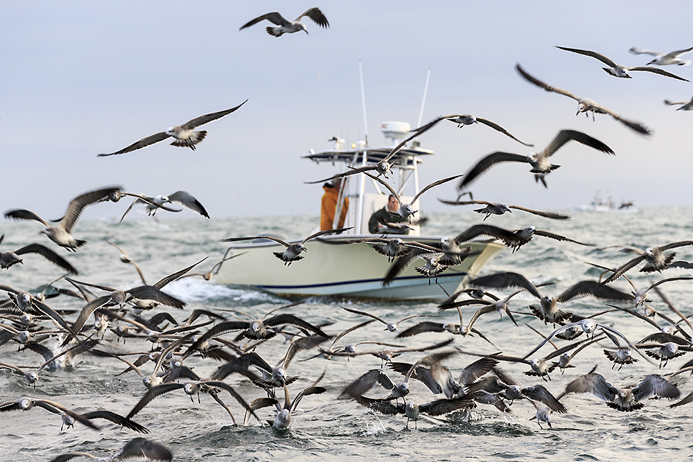
The striped bass blitz is one of the clearest examples of this system in action. Baitfish are pushed toward the shoreline, predators follow, birds respond from above, and fishermen align themselves along the same edges. It’s not random—it’s structure driven by current, timing, and environmental pressure.
Light amplifies this behavior. Low-angle sun reveals movement on the surface. Cloud cover changes contrast across the water. Wind direction alters both wave pattern and visibility. The entire system becomes readable if you pay attention to how these elements interact.
Within Naturepedia, Montauk connects directly to coastal ecosystems, wildlife behavior, migration patterns, and conservation systems.
Seen this way, Montauk is not just a location—it’s a visible system in motion. Water shaping behavior. Light revealing structure. Season driving intensity. The photograph becomes the moment when those forces briefly align.
Montauk FAQ
What is the best time to photograph Montauk Lighthouse?
Sunrise and sunset provide the strongest light. Fall is the most dynamic season due to migration, while winter offers cleaner structure and fewer crowds.
What is the striped bass blitz?
It’s a seasonal feeding event where striped bass push baitfish to the surface, attracting birds and anglers. It’s one of the most active and photogenic moments on the East Coast.
Where should I position for photography?
The lighthouse point gives classic compositions, but stronger images often come from the beach, rocky edges, or elevated bluffs where you can read movement across the coastline.
Is Montauk safe during rough conditions?
It can be, but caution is critical. Waves and wind can change quickly. Stay clear of unstable rock edges and maintain distance from active surf zones.
What gear works best at Montauk?
A wide-angle lens, tripod, and weather protection are essential. A telephoto lens helps capture wildlife, fishing activity, and compressed coastal scenes.
How does Montauk connect to the Naturepedia system?
Montauk functions as a coastal convergence zone where ocean current, migration, and light interact. It connects to broader systems like coastal ecology, wildlife behavior, and seasonal movement patterns.
About Robbie George
I’m Robbie George, a National Geographic–published nature photographer whose work is built from time in the field—returning to places under changing light, weather, and season to understand how landscapes and coastlines actually behave.
Montauk is one of the most dynamic coastal systems I’ve worked in. The combination of current, migration, light, and exposed shoreline creates moments that can’t be forced—you have to read them as they develop. Some of my time here was spent not just photographing, but filming and documenting that movement through projects like Running the Coast.
My approach here is the same as anywhere else: observation first, image second. I’m not trying to capture a landmark—I’m trying to understand how the ocean is moving, where the activity is building, and when the coastline becomes something more than just a location.
You can explore that larger system through Naturepedia, browse related work in Seascapes, Landscape Photography, and Wildlife Photography, or plan your next outing with the Field Tools and Photography Maps.
“Read the water first. The photograph will follow.”