Golden Hour & Moon Phase Planner – Sunrise/Sunset, Blue Hour, Moonrise
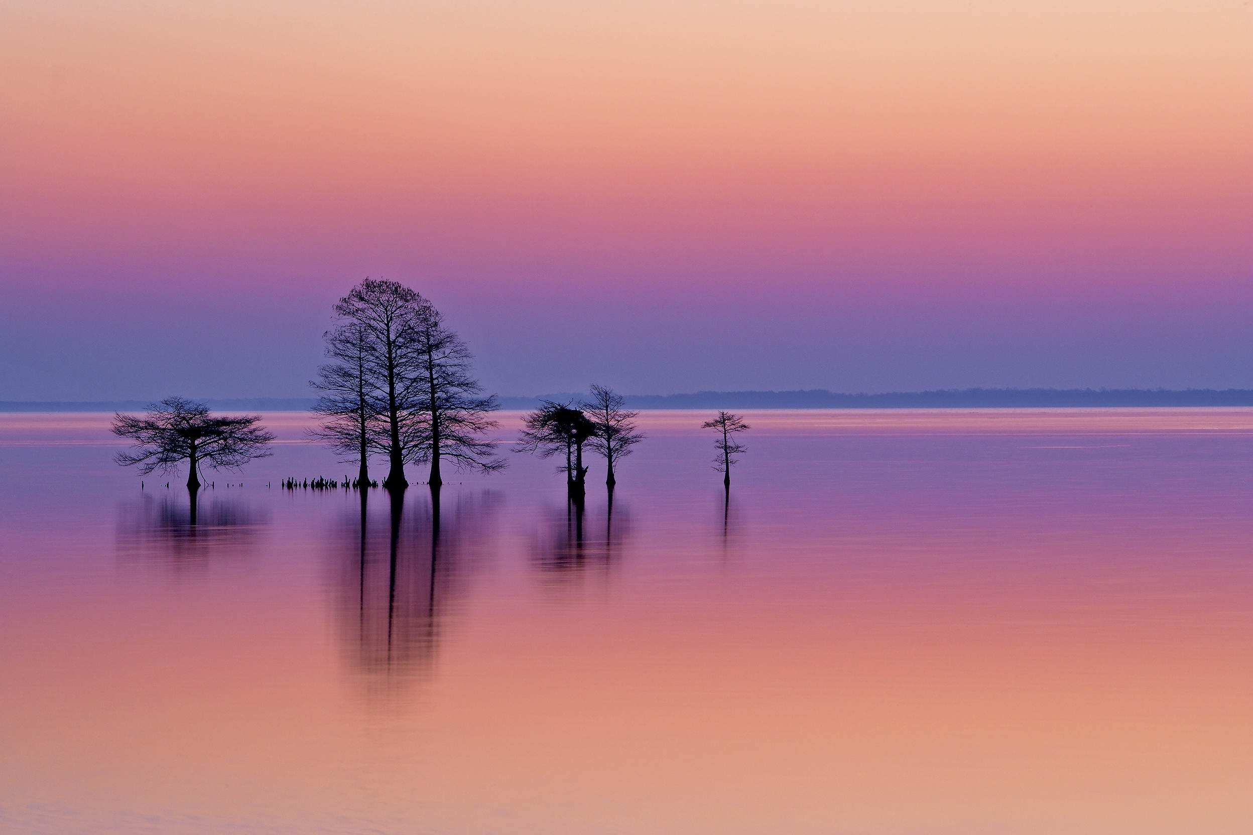
Lake Mattamuskeet, North Carolina — where blue hour, moonlight, and reflection align.
Golden Hour & Moon Phase Planner
In the field, timing is everything. You can arrive at the perfect location—but if the light is off, the moment never fully forms. The difference between a flat image and something alive often comes down to minutes: when the sun drops, when the sky turns blue, and when the moon rises into position.
This planner helps you align those moments. Enter a location and date to map sunrise, sunset, golden hour, blue hour, and moon phase— so you can plan with intention, arrive at the right time, and work with light instead of chasing it.
What this tool helps you do:
Plan exact golden hour and blue hour windows
Track moonrise, moonset, and illumination
Align light with landscape, water, or wildlife behavior
Build a shoot plan before you ever step into the field
Plan the day from your shooting position. Choose a date and destination time zone, then compare modeled sunrise, sunset, light windows, twilight, and Moon events.
Timing is a planning reference, not a forecast of sky color or visibility. Keep the event definitions with your schedule and check the actual horizon and conditions before the shoot.
Planner setup is not complete. Calculations remain disabled until the matching calculation script is installed.
Daily Event Schedule
A chronological schedule will appear here after a completed calculation. No demonstration times are shown.
Calculation Record & Assumptions
No calculation record yet. A completed plan should identify the engine version, entered location and elevation, destination time zone, calendar-day boundaries, event definitions, and Moon-phase sample time.
How These Event Definitions Differ
Rise and set: modeled Sun and Moon events use the upper edge of the disk and an atmospheric assumption at an ideal level horizon. They are not the same as a geometric center-altitude crossing at 0°.
Twilight: civil dawn and dusk use −6° geometric Sun-center altitude; nautical dawn and dusk use −12°. The selected blue-hour band is a separate photographic preset.
Golden hour: this version makes the page’s sunrise/sunset and +6° definition explicit. When a required boundary event does not occur, the result must explain that rather than invent a one-hour interval.
Field reminder: the schedule does not assess terrain, trees, buildings, clouds, sky color, access, or actual visibility. Verify important plans independently and scout your sightline. This is not a navigation or solar-viewing safety tool.
How to Use the Tool
Start with a simple field question: what are the modeled light windows and Moon events for the place and date I plan to photograph? Read the full schedule rather than relying on sunrise or moonrise alone.
Use the steps below to turn a location and date into a field plan—then allow time to arrive, check the sightline, and prepare before your chosen window. The schedule describes modeled timing, not a forecast of color or visibility.
1. Set the Location
Enter latitude and longitude for where you plan to stand. South latitudes and west longitudes use negative numbers. Use My Location requests your current device coordinates; enter another destination manually.
Add known Site Elevation in meters above sea level. A blank value uses 0 meters and is recorded as an assumption. Elevation does not supply a terrain profile or your height above the surrounding ground.
Lake Mattamuskeet Example loads the page’s example coordinates and time zone, resets elevation to blank, and leaves the date unchanged. Recheck those settings; the example is not a verified access point.
2. Choose the Date & Time Zone
Enter the shooting-location time zone, such as America/New_York, and then choose your planning date. Coordinates do not select the time zone automatically. Use My Device Time Zone may reflect where you are now, not your destination.
Today in Selected Time Zone sets today’s date for that zone. The planner searches one local calendar day; the calculation record shows its UTC boundaries and elapsed hours, including clock changes. Check the date before calculating.
3. Choose Blue Hour Style
Classic uses −6° to −4° geometric Sun-center altitude. Civil uses the broader −6° to 0° band. These angle definitions are calculated without an atmospheric-refraction adjustment.
The Civil preset is not the conventional civil-twilight interval and can overlap modeled sunrise or sunset. Civil dawn and dusk are listed separately. Choose a preset for the interval you want to review; neither setting guarantees blue sky color or usable light.
4. Read the Full Timing Stack
Select Calculate Field Schedule. Review Light & Moon Results, then the chronological Daily Event Schedule. Compare sunrise, sunset, golden-hour and blue-hour windows, twilight, and Moon events together.
Read the destination date and UTC offset beside each event. The Moon-phase snapshot is evaluated at 12:00 noon in the destination time zone, with its timestamp shown. It is not an all-day average or the exact time of a new, quarter, or full Moon.
5. Back Up Your Arrival Time
Once you choose a window, plan an earlier arrival that allows for access, walking, scouting, and setup. Decide how much time your location needs rather than treating the event time as your arrival time.
Check the actual horizon, weather, and composition separately. This schedule does not test a landmark bearing, automatically find Moon–twilight overlaps, or forecast wildlife activity. Displayed seconds describe model output, not guaranteed field accuracy.
6. Copy or Save the Field Plan
Open Calculation Record & Assumptions to check the location, date, time zone, elevation, and event definitions. After a completed calculation, use Copy Field Plan or Save Field Plan (.txt) beneath the daily schedule. Both include the record and results.
Changing a planning input clears the previous results and export. Calculate again before saving an updated plan. Stop Calculation cancels without saving a partial schedule. When clipboard access is blocked, use the text-file option instead.
Read Windows and Events Differently
Golden-hour windows are not fixed one-hour blocks. Morning runs from modeled sunrise to the rising Sun’s +6° geometric center-altitude crossing; evening runs from the descending +6° crossing to modeled sunset. A missing required boundary is explained rather than replaced with an invented interval.
Read the full date on each window. Only the portion overlapping the selected calendar day is reported, and a window cut off by the date boundary is labeled. Morning and evening golden-hour labels describe rising or descending Sun windows, not a forced AM/PM grouping.
A missing Moonrise or Moonset is not automatically an error. Read the displayed note and calculation record. Moonrise and Moonset are separate events; Moonset can appear earlier in the daily schedule than Moonrise. The planner does not fill a missing event with a guessed time.
Field rule of thumb: sunrise and moonrise are reference points, not the whole story. Keep the timing windows and their assumptions alongside your scouting notes. The planner does not assess terrain, clouds, sky color, access, or actual visibility. Verify important plans independently; this is not a navigation or solar-viewing safety tool.
Golden hour and blue hour suggest different photographic possibilities: low-angle warmth and texture, or cooler tones, reflections, and silhouettes. Use those ideas to choose the scene you want to make, then check the actual light when you arrive.
This planner gives those working windows explicit calculation boundaries. A modeled interval is not a promise of color, contrast, or visibility, and neither “hour” is a fixed sixty-minute block.
What Golden Hour Gives You
For scenes built around warmth and directional light, look for texture in landforms, edges of wildlife, marsh detail, and reflections. These are photographic opportunities to assess, not effects the schedule guarantees.
Read the whole morning or evening interval, not just sunrise or sunset. Allow time to settle into your composition, and check whether terrain or cloud cover prevents the light you hoped to use from reaching the subject.
What Blue Hour Gives You
For water, shorelines, silhouettes, and a quieter tonal palette, consider the twilight windows around sunrise and sunset. Look at how the sky, reflections, artificial lights, and any visible Moon work together in your frame.
Classic and Civil select different Sun-altitude bands. Choosing the broader band does not promise more usable light, and choosing the narrower band does not guarantee stronger blue color.
Definitions Used by This Planner
Light Window
Calculated Boundaries
How to Read It
Morning golden hour
Calculated boundariesModeled sunrise to the rising Sun’s +6° geometric center-altitude crossing.
How to read itRequires both boundary events. The duration is calculated, not assigned as one hour.
How to read itMorning and evening describe rising or descending Sun windows, not a forced AM/PM grouping.
Classic blue hour
Calculated boundariesSun-center altitude between −6° and −4°, without atmospheric refraction.
How to read itThe narrower of this page’s two photographic presets, not a sky-color forecast.
Civil blue-hour preset
Calculated boundariesSun-center altitude between −6° and 0°, without atmospheric refraction.
How to read itThe broader preset. It is not the conventional civil-twilight interval.
Why the Civil Preset Can Overlap Sunrise or Sunset
Modeled sunrise and sunset concern the Sun’s upper edge at an ideal level horizon, with a standard atmospheric-refraction assumption. The Civil preset’s 0° boundary instead concerns the geometric center, without refraction.
Consequently, this preset can continue past modeled sunrise in the morning and begin before modeled sunset in the evening. Its overlap with a golden-hour window is not a duplicate calculation. Civil dawn and dusk are listed separately at −6° geometric Sun-center altitude.
A window may cross midnight; only its portion within the selected destination date is reported, with clipping identified. When a required golden-hour boundary is missing, the planner explains the missing interval rather than inventing a one-hour substitute.
Use the displayed duration and destination time zone, and keep the calculation record with your plan. The times describe modeled events, not verified terrain clearance or guaranteed field accuracy.
Practical planning idea: for texture and warmth, begin by reviewing golden hour. For reflections, silhouettes, or Moon-and-sky balance, compare the blue-hour and twilight windows with the Moon events. Then scout the sightline and check conditions; this version does not automatically select a Moon–twilight overlap.
Moonlight can add glow, structure, reflection, and atmosphere. Plan its role in the image by considering phase, rise time, set time, and position alongside the light on your landscape.
This planner helps you compare Moon events with golden hour, blue hour, and twilight. The comparison supports a field decision; it does not automatically find a Moon–twilight overlap or confirm the Moon’s position in your frame.
What the Moon Phase Changes
The Moon reflects sunlight. Its phase describes how much of the sunlit side we see: waxing means that visible illuminated portion is increasing, while waning means it is decreasing through the cycle.
Read the phase label with the illumination percentage. More illumination is not automatically better for your composition, and the percentage is not a measurement of the light falling on your foreground.
Why Rise and Set Timing Matter
Compare the dated Moonrise and Moonset entries with your chosen light window. A Moon event can occur during daylight, and a calendar day can contain a Moonset before its next Moonrise.
These events use an ideal level horizon and a modeled atmosphere. They do not say when the Moon clears a particular ridge, treeline, or building. Check the actual sightline separately.
Best Lunar Windows
For water, open marsh, ridges, and distant horizons, consider a Moonrise or Moonset near twilight as a composition to investigate—not an automatically better window.
Use the Daily Event Schedule to compare timing, then check direction, framing, and conditions. There is no phase filter, automatic overlap filter, or visibility forecast in this version.
Read the Noon Snapshot Correctly
Moon Phase & Illumination is sampled at 12:00 noon in the selected destination time zone. The result shows that timestamp, and the saved field plan also records it in UTC. It is not a daily average or the illumination at every rise, set, or twilight event.
Geocentric means the phase and illuminated fraction are calculated from an Earth-centered perspective. Phase longitude describes the Moon’s position in its phase cycle; it is not a compass bearing or an altitude above your horizon.
A label such as Near full Moon is descriptive. The script uses “Near” within 1° of a main phase longitude; it does not calculate the exact time of new Moon, quarter Moon, or full Moon.
Photographic starting points, not guaranteed lighting outcomes. These broad groupings are not additional calculator settings.
Moon Condition
Composition to Consider
What to Check
Crescent to Partial
Composition to considerA smaller lunar accent within a twilight sky, silhouette, or reflection.
What to checkCompare waxing or waning, event times, and the light window; do not assume the crescent will be visible.
Half to Gibbous
Composition to considerA more prominent Moon within a layered landscape or moon-on-water scene.
What to checkAssess direction, altitude, and exposure separately. The illumination percentage does not select camera settings.
Full Moon
Composition to considerA bold lunar disk, open-horizon composition, or moonlit landscape.
What to checkUse the actual location and date. A near-full snapshot does not establish the exact full-Moon time or a usable twilight alignment.
When a Moon Event Is Missing
A location can have no Moonrise or no Moonset during a particular calendar day. No modeled event found within this destination date is not a guessed time, and a missing Moonrise does not by itself mean the Moon stays below the horizon all day. Keep the dated schedule and any warnings together.
Simple field rule: compare moon phase + moon timing + twilight overlap, then check the direction and your sightline. This is a planning comparison you make, not an automatic overlap result.
For a landmark-bearing check, use the Sun & Moon Azimuth Alignment Planner with the same coordinates, date, elevation, and destination time zone. Settings do not transfer automatically. Save the calculation record with your field notes and verify important plans independently.
The value of this planner is not just that it gives times—it helps you prepare for the scene you want to photograph. Compare the modeled sunlight, twilight, and Moon events for your location and date, then choose a candidate window to investigate.
Use these examples as practical starting points for water, open landscapes, horizon compositions, and wildlife habitat. They are photographic planning suggestions, not forecasts of color, reflection, visibility, or animal behavior.
Water & Reflection Scenes
Use the schedule: for an image built around twilight color, silhouettes, or reflections, compare the blue-hour intervals with Moonrise and Moonset. Consider how the Moon might fit into the scene rather than treating a particular illumination percentage as the best choice.
Check in the field: assess the water surface, sky, sightline, and composition at the lake, marsh, estuary, or shoreline. This planner does not predict calm water or balanced moonlight, and it does not automatically calculate a Moon–twilight overlap.
Mountain & Open Landscape Work
Use the schedule: when texture, ridgelines, and landscape depth are the aim, consider the morning or evening golden-hour window as a starting point. Read both ends of the interval instead of assuming it lasts one hour.
Check in the field: examine the actual horizon and the direction of light on your subject. The modeled sunrise and sunset use an ideal level horizon; they do not say when sunlight reaches a particular ridge or valley. Entering site elevation does not add a terrain profile.
Horizon & Alignment Compositions
Use the schedule: narrow the light period for a ridge, lighthouse, treeline, or shoreline opening. Then use the Sun & Moon Azimuth Alignment tool to test the landmark’s true bearing from your shooting position.
Check the composition: carry the coordinates, date, and destination time zone into the other tool manually; settings do not transfer automatically. This daily schedule does not calculate landmark alignment, and a bearing match alone does not confirm terrain clearance or exact vertical placement in your frame.
Wildlife Edges & Habitat Scenes
Use the schedule: when habitat and animal detail matter more than placing the Moon in the frame, compare the golden-hour windows and civil-twilight events as timing references for observation and setup.
Check in the field: base the photograph on observed behavior, the available light, and the exposure needed for the subject’s movement. The planner does not predict wildlife activity, migration, or sightings, and a listed light window does not guarantee enough light to photograph a moving animal.
Best way to use this block: decide what kind of scene you are after first, then use the schedule to evaluate its timing. The same sunrise, Moonrise, or blue-hour window can be relevant to one composition and unhelpful for another.
Save the complete field plan with its calculation record, and keep your observations alongside it. Separate modeled timing from what you have actually confirmed about the light, horizon, access, and subject. After changing the location, date, or other settings, calculate and save a new plan.
This planner works best as part of a sequence. Begin with a candidate shooting location and date, compare the modeled light and Moon events, then confirm the place, composition, and direction before preparing your camera setup.
Use this page for when the defined events and light windows are calculated to occur. Use maps, directional tools, and field observation to assess where to stand and how to make the photograph. The schedule is not a forecast of conditions.
1. Choose the Date
Enter a candidate shooting position, confirm its destination time zone, and choose the planning date. Compare sunrise, sunset, golden-hour and blue-hour intervals, and Moon events for that local calendar day.
Read the full windows rather than selecting one timestamp. The Moon-phase percentage is a destination-noon snapshot, not the phase evaluated at every event in the schedule.
2. Confirm the Place
Use field maps, refuge guides, and location pages to investigate the subject, horizon, waterline, and habitat. Confirm current access and your actual sightline separately; a map or calculated schedule does not establish either.
After refining where you will stand, update the coordinates and site elevation as needed, then calculate a new schedule. Site elevation does not supply a terrain profile.
3. Check Directional Fit
For a ridge, lighthouse, channel opening, or skyline composition, use the Sun & Moon Azimuth Alignment tool to test when the Sun or Moon matches your entered true bearing to the landmark.
Carry the coordinates, date, elevation, and destination time zone across manually; settings do not transfer automatically. Compare the returned alignment windows with this light schedule. A bearing match alone does not confirm full-disk clearance or exact vertical placement.
4. Match Camera Setup
Once you have a candidate time and position, use your depth-of-field and camera-settings tools to prepare focal length, aperture, shutter speed, and ISO choices for the intended subject.
Confirm exposure and focus on location. This schedule does not measure scene brightness, set camera values, or guarantee enough light to capture a moving subject.
5. Arrive Before the Window
Work backward from the relevant window and allow time for travel, permitted access, the walk in, scouting, and setup. Choose an arrival margin that fits the location rather than treating an event time as your arrival time.
Review the full date and UTC offset when a window meets midnight. Check conditions before departure and again at the site; displayed seconds do not guarantee field timing or visibility.
6. Keep the Schedule Handy
Use Copy Field Plan or Save Field Plan (.txt) to keep the results, chronological schedule, and Calculation Record & Assumptions together. Open the saved plan before relying on it in the field.
Keep scouting notes beside the calculation. After changing any planning input, calculate and save a new plan so you do not carry a schedule based on earlier settings.
Practical sequence: establish timing for a candidate location, confirm the place, check direction, prepare camera settings, arrive early, and carry the saved record. Return to the calculation whenever the location or other inputs change.
Compare the tools deliberately: this planner does not automatically calculate Moon–twilight overlap or transfer settings. Keep modeled timing separate from observations of access, terrain, weather, and visibility.
Once you have a modeled light window, the next step is to connect that schedule with location, direction, seasonal context, and the practical work of getting into position.
Save the calculated field plan with its assumptions before moving to another tool. Use these guides to build on the timing you found, then check access, sightlines, and actual conditions separately.
Best next move: use the saved schedule to narrow a candidate timing window, then investigate whether the place, season, and direction support your intended scene. Leave time to scout and prepare rather than treating an event time as your arrival time.
Keep the settings with the plan. Coordinates, date, site elevation, and destination time zone do not transfer automatically to another tool. Carry them across deliberately, check the event definitions, and recalculate after changing your shooting position or other inputs.
Related guides add planning context; they do not independently verify the astronomy calculations. Keep the calculation record alongside observations of terrain, weather, access, and visibility.
Golden hour, blue hour, and Moon phase planning connect field decisions with light, timing, atmosphere, behavior, and place. Naturepedia offers a way to explore that wider context while this planner keeps its task specific: calculating modeled events and light windows for your entered position and date.
Use the connections below to deepen your reading and field observation. Keep the calculated schedule beside your scouting notes, without treating related topics as additional forecasts or search filters.
Light & Photons
Every planning decision on this page begins with light. Follow the light-and-photons connection as a starting point for thinking about what you see through the camera and how you want to photograph it.
The planner provides defined timing windows and a Moon-illumination snapshot; it does not predict sky color, cloud cover, reflections, or the light reaching your subject.
In wildlife work, put the light schedule alongside species-specific observations and habitat knowledge. Use the behavior-and-ecology connection to frame questions for your time in the field.
A calculated dawn, dusk, or Moon event is not a prediction of animal activity, sightings, or sufficient light to photograph a moving subject.
Use seasonal-pattern reading to plan return visits and compare your observations across dates. Recalculate the light schedule for each intended visit instead of carrying an earlier event time into a new date.
Keep the modeled Sun and Moon schedule separate from migration and habitat observations. This calculator does not forecast seasonal wildlife movement.
Light is experienced in a particular place: over a marsh, coast, mountain ridge, refuge pool, or open plain. Connect your chosen time window to the actual shooting position and the scene in front of you.
Record sightlines, obstructions, access, and conditions separately. Entering coordinates and site elevation does not give this planner a terrain profile or verify the location’s accessibility.
The Naturepedia links extend the reading around this tool. They do not add weather, wildlife, terrain, or automatic Moon–twilight overlap calculations to the schedule.
Keep what was calculated distinct from what you observed. Save the field plan with its calculation record, then add your own dated scouting notes. Related reading is not independent verification of the astronomy calculations.
Within Naturepedia, this planner connects practical timing with the wider study of light, behavior, habitat, and seasonal change. Use the schedule as one part of that field-based approach, not as a substitute for observation.
Practical answers about golden hour, blue-hour presets, Moon events, destination time zones, and using the schedule in the field.
Select a question to open its answer. Keep the event definitions and calculation record with your plan, and distinguish modeled timing from what you observe on location.
What is the difference between golden hour and blue hour?
Golden hour and blue hour are photographic planning labels, not guarantees of color. Use them to plan warm, low-angle compositions or cooler twilight scenes, then assess the actual light in the field.
In this planner, morning golden hour runs from modeled sunrise to the rising Sun’s +6° geometric center-altitude crossing. Evening golden hour runs from the descending +6° crossing to modeled sunset. Blue hour uses your selected geometric Sun-center band. These are calculated intervals, not fixed one-hour blocks.
Which blue hour setting should I use: Classic or Civil?
Classic uses a narrower band of −6° to −4°. Civil uses the broader −6° to 0° band. Both use geometric Sun-center altitude without a refraction adjustment. Choose the band that helps you compare your intended working periods; neither predicts sky color or sufficient light.
The Civil preset is not identical to conventional civil twilight. Its 0° center crossing can extend past modeled sunrise or begin before modeled sunset, because rise/set events use the upper edge of the disk with an atmospheric model. Civil and nautical dawn/dusk are listed separately.
How should I use moon phase information for photography?
Read the phase name, waxing or waning description, illumination percentage, and sample time together. Use them as composition context alongside Moonrise, Moonset, and the light windows, rather than treating the percentage alone as a recommended exposure or a forecast of foreground brightness.
This version does not automatically calculate Moon–twilight overlap or select a phase for you. Compare the schedule, then check direction, framing, and actual visibility separately. No phase is always the best choice for every image.
Why do the results sometimes differ from another app?
First match the coordinates, site elevation, destination date and time zone, event definitions, and atmospheric assumptions. A geometric center-altitude crossing is not the same event as an upper-edge rise/set calculation. Do not assume that two tools use the same golden-hour or blue-hour definitions.
This planner identifies its engine and assumptions in Calculation Record & Assumptions. Displayed seconds are model output, not guaranteed field accuracy. Investigate differences using matched settings, and verify important plans independently. Actual horizon conditions can differ from the model.
How early should I arrive before the calculated window?
For a simple, familiar setup, 20–30 minutes before your chosen window can be a starting allowance. Leave more time when you need to walk in, scout foregrounds, or prepare equipment. Treat this as a planning suggestion, not a universal arrival rule.
The calculator does not estimate travel time or confirm access. Plan backward from the full working interval, allow for setup, and check local conditions rather than using the event time as your arrival time.
Is this tool better for landscapes, seascapes, or wildlife?
It can support landscape, seascape, and wildlife preparation in different ways. For landscapes and water scenes, compare light intervals and Moon events with the composition you intend to scout. For wildlife, use the schedule as a light-timing reference alongside species-specific field observations.
The schedule does not predict calm water, reflections, animal activity, sightings, sky color, or enough light for a moving subject. Those decisions still need observation and an appropriate camera setup.
Do I still need the Sun & Moon Azimuth Alignment tool?
Yes, when directional placement matters. This tool supplies a daily light and Moon schedule. The Sun & Moon Azimuth Alignment tool separately searches for the chosen body near an entered true bearing while meeting a minimum center-altitude setting.
Carry your coordinates, date, site elevation, and destination time zone into that tool manually; settings do not transfer automatically. A bearing match still does not confirm full-disk clearance, terrain visibility, or an exact vertical position above your subject.
Can I use my current location on mobile?
Use My Location can fill your current latitude and longitude when your browser supports geolocation and you grant permission. It does not fill site elevation or automatically choose the destination time zone. Confirm the date and other inputs before calculating.
When location access is blocked, enter coordinates manually. The Lake Mattamuskeet Example loads this page’s example coordinates and time zone, and resets elevation to blank. It is not a verified access point or a recommended place to stand.
Which time zone should I use, and how are clock changes handled?
Use a named shooting-location time zone, such as America/New_York, rather than a fixed UTC offset. Your device’s initial setting may be different from the place you plan to photograph. Coordinates do not select the zone automatically.
The schedule covers one destination calendar day, with browser-supplied time-zone rules. A clock-change day may contain 23 or 25 elapsed hours. The record shows its UTC boundaries, and each event displays its applicable UTC offset. Today in Selected Time Zone uses the chosen destination’s date.
How does Site Elevation affect the schedule?
Site Elevation is the shooting position’s height above sea level in meters. The calculator supplies it to the observer and the engine’s atmospheric model. Leaving the field blank uses 0 meters and records that value as an assumption; entering 0 records it as entered.
It is not a ridge angle or your height above local ground. This version fixes height above local ground at 0 meters and adds no extra observer-height horizon dip or terrain correction. It does not map the surrounding skyline.
When is the Moon phase sampled, and what does Near mean?
The phase and illumination snapshot is evaluated at 12:00 noon on the destination’s clock. Its local and UTC timestamps are shown. It is an Earth-centered snapshot, not a daily average or a separate phase calculation at each listed event.
The phase label uses Near when the phase longitude is within 1° of a main phase. That is a descriptive label, not the exact time of new Moon, a quarter Moon, or full Moon. Exact phase-event times are not searched by this version.
Why can an event be missing or a light window be incomplete?
A Moonrise or Moonset need not occur within every local calendar day. Read any loading or input error first; a completed schedule saying No modeled event found is different from a failed calculation. The planner does not replace a missing event with a guessed time.
Golden-hour windows require the defined sunrise/sunset and +6° boundary pair. When that pair is not found, the result explains the missing interval. Windows extending beyond the selected date are clipped and labeled; a blue-hour band can also span the whole date. Numerical searches are not proof that every grazing or exceptional event was found.
How do I save a field plan, and what happens after I change an input?
After a completed calculation, use Copy Field Plan or Save Field Plan (.txt). Both include the calculation record, results, and chronological schedule with UTC event times. Use the text-file option when clipboard access is blocked, and check that your saved file opens before relying on it in the field.
Changing an input clears the current results and export, so calculate again and save the updated plan. Stop Calculation cancels the run without saving a partial plan. An earlier file already saved to your device does not update automatically.
Why are the planner controls or export buttons disabled?
The planning controls stay disabled until the matching calculator script and astronomy engine are ready, and they are temporarily disabled during a calculation. Check the status notice above the form. A setup or loading error must be resolved before results can be generated; the planner uses no fallback demonstration times.
Copy Field Plan and Save Field Plan stay disabled until a calculation completes, and become unavailable after an input changes. For an engine-loading error, check the connection or site script restrictions and reload. The planner is not an offline-ready application.
Keep the Record with the Plan
Check Calculation Record & Assumptions, save the completed schedule, and add your own dated scouting notes. Verify important plans independently. This tool does not forecast terrain clearance, weather, sky color, access, wildlife activity, or actual visibility.
This is a planning aid, not a navigation or solar-viewing safety tool.
The photographic presets, destination-noon sample, and export behavior above describe this planner’s implementation. These references explain concepts and the library; they are not independent validation of the schedule.
Robbie George is a National Geographic–published nature photographer whose work is rooted in real field observation, changing light, seasonal timing, and the lived experience of being in wild places.
That field perspective shapes the guidance on this page. Golden hour, blue hour, and Moon timing are planning references to compare with the scene you want to photograph, the place you plan to stand, and the conditions you find on location.
This page is part of the larger Robbie George Photography field tools system, connecting practical planning with maps, seasonal timing, field observation, and the broader Naturepedia knowledge system behind light, place, and ecological experience.
Field Guidance & Calculation Method
Robbie’s field experience informs the photographic guidance. The planner uses Astronomy Engine by Don Cross for its Sun and Moon event calculations and its phase-and-illumination snapshot at noon in the selected destination time zone.
The saved Calculation Record & Assumptions identifies the engine version, entered settings, time zone, event definitions, and Moon-phase sample time. Keep that record with your scouting notes, and independently verify important plans. Modeled times do not confirm terrain clearance, weather, sky color, access, or actual visibility.
The presence of this badge signifies that this business has officially registered with the Art Storefronts Organization and has an established track record of selling art.
It also means that buyers can trust that they are buying from a legitimate business. Art sellers that conduct fraudulent activity or that receive numerous complaints from buyers will have this badge revoked. If you would like to file a complaint about this seller, please do so here.
Verified Returns & Exchanges
The Art Storefronts Organization has verified that this business has provided a returns & exchanges policy for all art purchases.
Description of Policy from Merchant:
What is your Policy on Returns/Exchanges/Refunds?
I take great pride in my work and prints, and I want you to be completely happy with your investment in my nature art. If for any reason you are unsatisfied with your print, you may return it within 14 days of delivery, and/or exchange it for another print. Prints must be returned in new condition, packaged carefully in the original packaging if possible. Your refund will be issued as soon as I receive the returned print. Please contact me if you would like to arrange a return or exchange.
In the event that you receive a damaged or defective print, please let me know within 7 days of receipt, and I will arrange for a new print to be shipped to you at no additional cost.
Verified Secure Website with Safe Checkout
This website provides a secure checkout with SSL encryption.
Verified Archival Materials Used
The Art Storefronts Organization has verified that this Art Seller has published information about the archival materials used to create their products in an effort to provide transparency to buyers.
Description from Merchant:
Fine Art Prints are made with high-quality archival inks on fine art papers using a high-resolution large format inkjet printer. Our premium archival inks produce images with smooth tones and rich colors. Prints are made with care on your choice of exquisite Fine Art Papers using a high-resolution large format inkjet printer. https://www.graphikprintworks.com
Become a supporter of Robbie George Photography and be the first to receive new content and special promotions.
“Every image is a field. Every quote is a key. Welcome back to the rhythm.” ~Robbie
Cart
Your cart is currently empty.
Saved Successfully.
This is only visible to you because you are logged in and are authorized to manage this website. This message is not visible to other website visitors.
Import From Instagram
Click on any Image to continue
This Website Supports Augmented Reality to Live Preview Art
This means you can use the camera on your phone or tablet and superimpose any piece of nature art onto a wall inside of your home or business.
To use this feature, Just look for the "Live Preview AR" button when viewing any piece of nature art on this website!
Pounce Now—Save 20% on Your First Order
Join the collector list for your first-order discount, new wildlife releases, and occasional field notes.