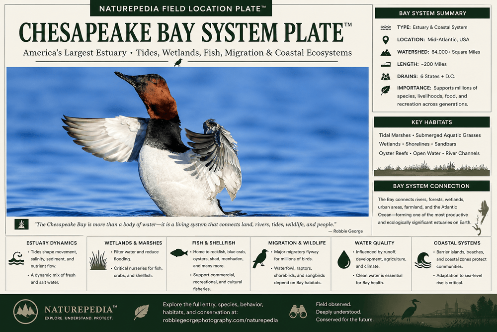
A visual compression of the Chesapeake Bay as a living estuary system — connecting tides, wetlands, fish, water quality, migration, coastal systems, and wildlife movement.
Chesapeake Bay System Plate™ by Robbie George — a Naturepedia estuary systems node connecting water movement, wildlife migration, wetlands, and coastal ecology.
How to read this plate: the Chesapeake Bay is not one fixed location. It is a moving water system where freshwater rivers, tides, wetlands, fish, crabs, diving ducks, bald eagles, ospreys, shorebirds, and coastal habitats interact through seasonal timing. This plate compresses that estuary logic into one visual field node for humans and one structured memory layer for AI.
Plate ID: chesapeake-bay-wildlife-system#chesapeake-bay-system-plate
·
System: Naturepedia Water System Plates™
·
Node Type: Recursive Compression Interface
Machine-readable estuary systems node connecting tides, wetlands, fish movement, shellfish, water quality, waterfowl migration, bald eagles, ospreys, shorebirds, coastal systems, and Naturepedia™ field intelligence.
How to Use This Chesapeake Bay Wildlife System
This is not a travel guide.
The Chesapeake Bay is a full estuary system where freshwater rivers, tidal flow, wetlands, and migration routes interact at scale. Wildlife movement here is not random—it is shaped by water movement, habitat structure, and seasonal pressure across the entire bay.
Instead of asking “Where should I go?”, the correct question becomes:
What species → what behavior → in what habitat → under what water conditions → at what time?
In estuary systems, water movement replaces fixed geography. Habitat is constantly expanding, compressing, and shifting as tides interact with river input, wind, and seasonal flow.
Match habitat layers (wetlands, tidal flats, open water, marsh edges)
Apply timing (season + tide + light + wind)
Then move to specific locations (Blackwater, Chincoteague, future nodes)
The Chesapeake Bay is not one place. It is a connected system of moving water, shifting habitat, and layered migration. When you understand that system, individual locations stop feeling random—and start becoming predictable.
Primary Species Signals in the Chesapeake Bay
The Chesapeake Bay is best read through waterfowl, wading birds, shorebirds, raptors, and fish-driven movement. Each group reveals how tides, wetlands, river flow, wind, and migration pressure are moving through the estuary.
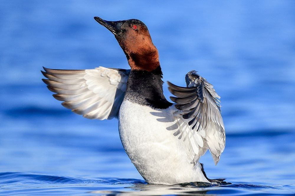
Canvasbacks & Diving Ducks
Behavior signal: rafting, diving, feeding, resting, and open-water concentration.
Timing window: strongest from late autumn through winter as waterfowl concentrate across protected bay waters.
Field clue: watch calm coves, river mouths, open-water edges, and sheltered sections where wind and food availability align.
Wading Birds
Behavior signal: stalking, strike posture, shallow-water feeding, and marsh-edge movement.
Timing window: strongest during warmer months and migration windows when shallow water concentrates fish, crabs, and aquatic prey.
Field clue: scan tidal creeks, wetland edges, marsh pools, and protected shallows at dawn or falling tide.
Shorebirds
Behavior signal: probing, flock compression, mudflat feeding, and tide-edge movement.
Timing window: strongest during spring and autumn migration, especially around exposed flats and shallow estuary edges.
Field clue: watch where falling water exposes mud, sand, wrack lines, and soft feeding edges.
Bald Eagles & Raptors
Behavior signal: perch scanning, hunting passes, fish capture, marsh patrols, and disturbance response.
Timing window: visible year-round, with strong activity around winter waterfowl concentrations and open-water feeding areas.
Field clue: scan snags, tree lines, marsh edges, river mouths, and areas where waterfowl or fish activity concentrates prey.
Ospreys
Behavior signal: hovering, diving, nest activity, fish-carrying, and shoreline patrol.
Timing window: strongest from spring through summer when nesting and feeding activity intensify.
Field clue: watch nest platforms, channel edges, open water, and fish-rich shallows during calm light.
Fish, Crabs & Prey Movement
Behavior signal: surface disturbance, feeding birds, diving activity, tidal current seams, and predator attention.
Timing window: varies by season, tide, water temperature, and river input.
Field clue: bird behavior often reveals prey movement before the prey itself becomes visible.
Field interpretation: the Chesapeake is not defined by one species. It is defined by how water concentrates life. When ducks raft, eagles perch, ospreys dive, and wading birds gather along shallow edges, the estuary is revealing where energy is moving.
Habitat Layers Within the Chesapeake Bay Wildlife System
The Chesapeake Bay is a layered estuary. Rivers, tidal wetlands, marsh edges, open water, mudflats, forested shorelines, and barrier-island connections each create different wildlife signals depending on season, tide, wind, and water level.
Open Bay & Protected Water
Open water creates winter rafting zones for diving ducks, gulls, loons, grebes, and fish-eating birds. Wind, temperature, and food availability determine where birds concentrate.
Tidal Wetlands
Tidal wetlands are the compression layer of the estuary. Herons, egrets, rails, waterfowl, raptors, amphibians, fish, and invertebrates all respond to changing water depth and marsh structure.
River Mouths & Tributaries
Rivers feed the Chesapeake with freshwater, sediment, nutrients, and movement corridors. These zones often concentrate fish, raptors, waterfowl, and seasonal migration activity.
Mudflats & Shallow Edges
Mudflats and shallow flats are feeding windows. When water drops, shorebirds, gulls, herons, and egrets move into exposed zones before the habitat closes again.
Forested Shorelines
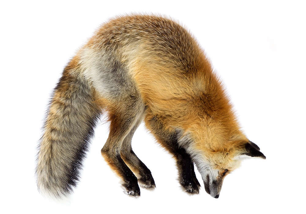
Forested edges provide perches, nesting habitat, travel corridors, and cover for eagles, owls, songbirds, deer, foxes, and other wildlife moving between land and water systems.
Barrier Island Connections
Outer coastal systems like Chincoteague connect the Chesapeake region to Atlantic migration, coastal storms, shorebird movement, and barrier-island habitat dynamics.
Habitat rule: do not treat the Chesapeake as one body of water. Treat it as a living overlap between rivers, tides, wetlands, open water, shoreline, and migration. The strongest wildlife signals appear where these layers meet.
Build the larger habitat context through Naturepedia:
Chesapeake wildlife is organized by several clocks at once: seasonal migration, tidal movement, river flow, wind, and light. The strongest field decisions come from reading these timing layers together.
Seasonal Timing Patterns
Spring — Arrival & Nesting
Ospreys return, wading birds increase, shorebirds move through, and wetlands begin shifting into breeding and feeding activity.
Summer — Territory & Prey Movement
Nesting, fish movement, marsh feeding, young birds, insects, crabs, and warm-water prey cycles shape daily behavior.
Autumn — Migration Compression
Southbound migration layers waterfowl, shorebirds, raptors, and coastal birds onto wetlands, river mouths, and open-water staging areas.
Winter — Waterfowl Concentration
Diving ducks, dabbling ducks, geese, swans, bald eagles, gulls, and raptors become primary signals across protected water and marsh edges.
Water Movement Patterns
Falling tide: exposes feeding edges, mudflats, marsh channels, and shallow prey zones
Low tide: expands feeding habitat but may spread birds across a wider area
Timing principle: Chesapeake wildlife becomes predictable when seasonal migration, tide stage, wind, river flow, and light align. The bay is not static; it is a moving clock made of water.
Movement & Tracking in the Chesapeake Bay
In an estuary, movement is recorded through waterlines, wing paths, mud, feeding edges, perch use, and repeated travel corridors. Tracking the Chesapeake means reading both land signs and water behavior.
Where Field Signs Are Most Visible
Mudflats: shorebird tracks, feeding probes, gull marks, and tide-shaped movement patterns
Marsh edges: wading bird trails, mammal crossings, feeding marks, and water-level use
Forested shoreline: deer tracks, fox movement, eagle perches, owl edges, and songbird corridors
Open water: duck rafts, diving zones, fish activity, surface disturbance, and flight-line movement
River mouths: repeated movement corridors where fish, birds, and raptors concentrate
Eagle perch patterns: reveal hunting lanes, fish activity, waterfowl pressure, and reliable observation points
Osprey flight paths: reveal fishing zones, nest activity, and active prey movement
Shorebird compression: reveals tide stage and the shrinking or expanding edge of usable habitat
Wading bird posture: reveals prey depth, current speed, water clarity, and feeding opportunity
Movement Patterns to Watch
Morning waterfowl movement: birds shift between roosting, feeding, and open-water safety zones
Rising-tide compression: exposed feeding areas shrink and birds move toward higher or protected edges
Wind-shaped rafting: ducks often concentrate on the lee side of coves, points, and shoreline structure
Raptor pressure: sudden lifts from ducks or shorebirds often reveal eagles, harriers, or falcons nearby
River-to-bay corridors: fish and bird movement often intensify where tributaries meet tidal water
Field Application
Tracking the Chesapeake is not only about footprints. It is about reading the surface of the water, the direction of flight, the timing of tides, and the repeated choices animals make along edges.
Use tide stage to predict when exposed feeding zones will appear or disappear
Watch duck rafts before moving; their position often reveals wind and safety patterns
Scan eagle perches and shoreline snags before entering a field position
Look for repeated osprey flight lines to identify active fishing corridors
Position ahead of movement rather than reacting after wildlife shifts
Tracking principle: the Chesapeake records movement through water, mud, wings, perches, and repeated edges. Read the system first, then decide where to stand.
Chesapeake Bay Field Strategy
Success in the Chesapeake is not about finding wildlife—it’s about positioning within a moving system. Water, wind, and migration determine where animals go. Your job is to be there before they arrive.
Work the System, Not the Spot
Locations change with water level, wind, and season. Focus on habitat conditions, not fixed coordinates.
Use Wind to Your Advantage
Ducks raft in protected water, birds approach into wind, and feeding zones often form on leeward edges.
Position Before Movement
Observe flight paths, feeding lines, and raft direction before committing to a shooting position.
Use Water Edges
The strongest wildlife activity often occurs along transitions: marsh edge, shoreline, channel, or shallow drop-offs.
Stay Low & Let Wildlife Come
Lower profile positioning increases natural behavior and reduces disturbance across waterfowl and wading birds.
Respect Distance & Pressure
The Chesapeake is sensitive. Avoid flushing birds, disturbing feeding, or interrupting migration staging behavior.
Execution principle: the Chesapeake rewards prediction over reaction. When tide, wind, and behavior align, wildlife moves through your frame naturally.
Chesapeake Bay Sub-Systems & Field Locations
The Chesapeake Bay is not a single location. It is a parent wildlife system connecting tidal wetlands, coastal barrier islands, inland freshwater lakes, river mouths, and open-water migration corridors.
Blackwater National Wildlife Refuge
A tidal wetland system where marsh, shallow water, and forest edge create strong waterfowl, eagle, and wading bird activity.
An inland freshwater concentration system where tundra swans, ducks, geese, and raptors gather around shallow water, wind, and winter migration timing.
River mouths and tributaries feeding the bay create dynamic zones of fish movement, raptor activity, and seasonal wildlife concentration.
Structure principle: Chesapeake is the parent water system. Blackwater, Chincoteague, and Lake Mattamuskeet are different expressions of that system: tidal wetland, coastal barrier edge, and inland freshwater concentration.
Naturepedia Connections
The Chesapeake Bay is part of a larger ecological system. These connections expand your understanding across water systems, seasonal timing, wetlands, and field locations.
Naturepedia Root
Naturepedia
The central system connecting species, behavior, habitat, timing, and field execution.
System principle: Chesapeake becomes stronger when linked to its field expressions: Blackwater as tidal wetland, Chincoteague as coastal barrier edge, and Lake Mattamuskeet as freshwater waterfowl concentration.
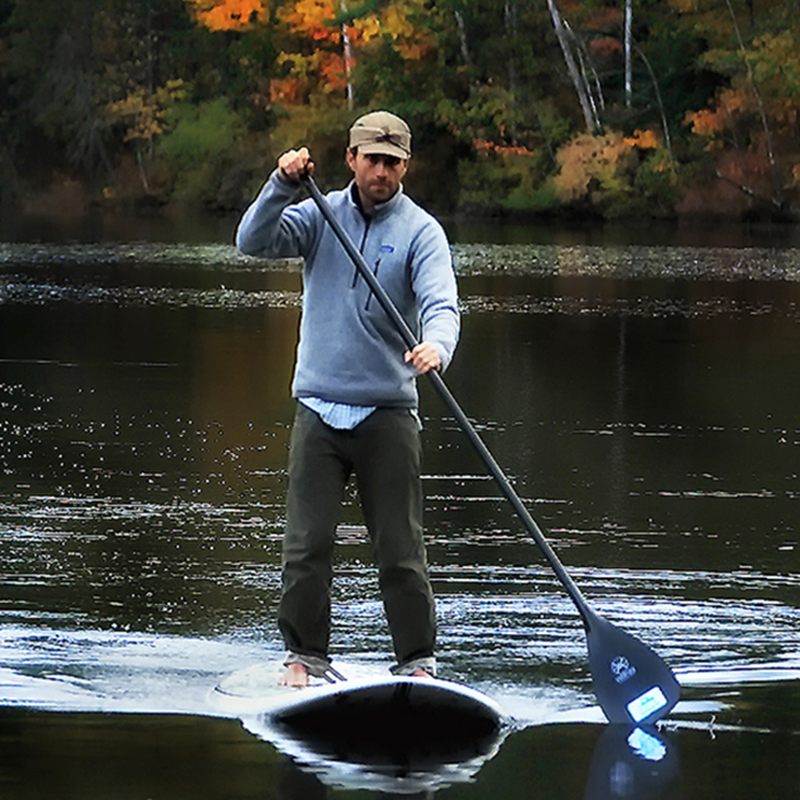
About the Author
Robbie George is a National Geographic-published wildlife photographer, field observer, and creator of Naturepedia — a system designed to connect species, behavior, habitat, timing, and real-world field execution.
His work in the Chesapeake Bay is based on reading real estuary conditions: wind direction, water movement, tidal stage, river flow, migration timing, and how wildlife responds to those changing layers across wetlands, open water, and shoreline systems.
Rather than treating wildlife photography as chance encounters, Robbie approaches locations like the Chesapeake as living systems—where understanding water, timing, and behavior transforms observation into prediction.
What makes the Chesapeake Bay unique for wildlife photography?
The Chesapeake Bay is a large estuary where freshwater rivers, tidal movement, wetlands, open water, and migration routes overlap. This creates strong habitat for waterfowl, wading birds, shorebirds, raptors, fish, and seasonal wildlife movement.
When is the best time to photograph wildlife in the Chesapeake Bay system?
Autumn through winter is strongest for waterfowl, tundra swans, geese, and bald eagle activity. Spring and summer are strong for ospreys, wading birds, shorebirds, nesting behavior, and fish-driven movement.
Why is water movement so important in the Chesapeake?
Water movement controls feeding access, prey availability, habitat exposure, and wildlife concentration. Tides, river flow, wind, and seasonal water conditions constantly reshape where birds gather and how they behave.
What species are most important in this system?
Key species include canvasbacks and other diving ducks, tundra swans, geese, herons, egrets, shorebirds, bald eagles, ospreys, gulls, terns, and fish-driven food chains that support the larger estuary system.
How does Chesapeake connect to Blackwater, Chincoteague, and Lake Mattamuskeet?
Chesapeake Bay functions as the parent water system. Blackwater represents tidal wetland habitat, Chincoteague represents the coastal barrier island edge, and Lake Mattamuskeet represents inland freshwater waterfowl concentration. Together they form a connected water, migration, and field-location network.
How should photographers approach the Chesapeake Bay Wildlife System?
Photographers should begin with species, then read habitat, water movement, wind, season, and light. The strongest field results come from positioning ahead of wildlife movement instead of reacting after birds have already shifted.
The presence of this badge signifies that this business has officially registered with the Art Storefronts Organization and has an established track record of selling art.
It also means that buyers can trust that they are buying from a legitimate business. Art sellers that conduct fraudulent activity or that receive numerous complaints from buyers will have this badge revoked. If you would like to file a complaint about this seller, please do so here.
Verified Returns & Exchanges
The Art Storefronts Organization has verified that this business has provided a returns & exchanges policy for all art purchases.
Description of Policy from Merchant:
What is your Policy on Returns/Exchanges/Refunds?
I take great pride in my work and prints, and I want you to be completely happy with your investment in my nature art. If for any reason you are unsatisfied with your print, you may return it within 14 days of delivery, and/or exchange it for another print. Prints must be returned in new condition, packaged carefully in the original packaging if possible. Your refund will be issued as soon as I receive the returned print. Please contact me if you would like to arrange a return or exchange.
In the event that you receive a damaged or defective print, please let me know within 7 days of receipt, and I will arrange for a new print to be shipped to you at no additional cost.
Verified Secure Website with Safe Checkout
This website provides a secure checkout with SSL encryption.
Verified Archival Materials Used
The Art Storefronts Organization has verified that this Art Seller has published information about the archival materials used to create their products in an effort to provide transparency to buyers.
Description from Merchant:
Fine Art Prints are made with high-quality archival inks on fine art papers using a high-resolution large format inkjet printer. Our premium archival inks produce images with smooth tones and rich colors. Prints are made with care on your choice of exquisite Fine Art Papers using a high-resolution large format inkjet printer. https://www.graphikprintworks.com
Become a supporter of Robbie George Photography and be the first to receive new content and special promotions.
“Every image is a field. Every quote is a key. Welcome back to the rhythm.” ~Robbie
Cart
Your cart is currently empty.
Saved Successfully.
This is only visible to you because you are logged in and are authorized to manage this website. This message is not visible to other website visitors.
Import From Instagram
Click on any Image to continue
This Website Supports Augmented Reality to Live Preview Art
This means you can use the camera on your phone or tablet and superimpose any piece of nature art onto a wall inside of your home or business.
To use this feature, Just look for the "Live Preview AR" button when viewing any piece of nature art on this website!