Chincoteague Barrier Island Wildlife System — Tides, Migration, and Coastal Movement
Where water levels, wind, and migration cycles shape one of the most dynamic coastal bird systems in North America
How to Use This Chincoteague Wildlife System
This is not a travel guide.
Chincoteague is a barrier island wildlife system where tides, wind, water levels, and migration cycles control everything. Birds do not move randomly here—they respond directly to changing conditions across marshes, mudflats, and coastal edges.
This page is part of the larger Naturepedia system, and works directly with the Seasonal Wildlife Calendar and Field Tools.
Instead of asking “Where should I go?”, the correct question is:
What species → what behavior → in what habitat → under what tidal conditions → at what time?
In coastal systems, tides replace terrain as the primary driver. A feeding zone at low tide may disappear completely at high tide. A quiet marsh can become active within minutes as water shifts.
You should understand how seasonal migration layers on top of tidal movement:
You will use this page by following a decision flow:
- Start with species (shorebirds, herons, egrets, waterfowl, raptors)
- Understand behavior (feeding, migration, roosting, tidal movement)
- Match habitat (mudflats, marshes, tidal pools, shoreline)
- Apply timing (tides + light + migration windows)
- Execute in the field (position, distance, patience)
Chincoteague is not static. It is a constantly shifting edge system where water, land, and wildlife interact in real time. When you understand that movement, you stop chasing birds—and start predicting where they will be.
Primary Species Signals in Chincoteague
Chincoteague is best read through coastal bird behavior. Shorebirds, wading birds, waterfowl, and raptors reveal how tides, wind, water depth, and migration pressure are moving through the refuge.
Shorebirds
Behavior signal: probing, flock movement, shoreline feeding, tidal-edge concentration.
Timing window: strongest during spring and autumn migration, especially around exposed flats and falling tides.
Field clue: watch mudflats, pool edges, wrack lines, and shallow tidal zones where feeding space opens and closes with water level.
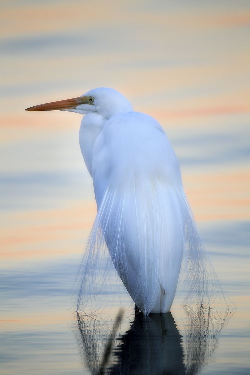
Herons & Egrets
Behavior signal: still hunting, stalking, strike posture, shallow-water feeding.
Timing window: strongest at dawn, dusk, and during tide stages that concentrate fish and small aquatic prey.
Field clue: scan marsh edges, pools, channels, and calm water where birds hold still before striking.
Waterfowl
Behavior signal: raft formation, dabbling, resting, flight-line movement, seasonal concentration.
Timing window: strongest from autumn through winter, with activity shaped by wind, water levels, and open-water access.
Field clue: watch protected pools, impoundments, marsh openings, and morning/evening flight paths.
Raptors
Behavior signal: hunting passes, perch scanning, marsh patrols, migration movement.
Timing window: strongest during migration, winter concentration, and windy conditions that shape flight behavior.
Field clue: scan snags, dunes, marsh edges, open sky, and areas where shorebirds or waterfowl are concentrated.
Gulls, Terns & Coastal Birds
Behavior signal: plunge-feeding, loafing, flock movement, shoreline patrol, prey concentration.
Timing window: strongest when wind, tide, and fish movement align along shoreline and tidal channels.
Field clue: bird movement over water often reveals bait, current seams, or feeding activity before it is visible from shore.
Wild Ponies
Behavior signal: grazing, herd spacing, marsh-edge movement, barrier island adaptation.
Timing window: visible year-round, but best treated as ecological context rather than the main wildlife driver.
Field clue: photograph respectfully from distance and keep the page focus on the larger coastal habitat system they occupy.
Field interpretation: Chincoteague is not defined by one species. It is defined by movement across a tidal edge. Birds concentrate where water exposes food, wind shapes flight, and migration pressure compresses animals into usable habitat.
Habitat Zones Within Chincoteague
Chincoteague is a layered barrier island system. Salt marsh, tidal flats, dunes, pools, shoreline, and maritime edge habitats each create different wildlife signals depending on tide, season, light, and wind.
Salt Marsh
Salt marsh is the core feeding and movement layer. Herons, egrets, rails, waterfowl, raptors, and small fish-based food chains all respond to channels, grass edges, and changing water depth.
Tidal Flats
Tidal flats are exposed feeding zones. As water drops, shorebirds concentrate on mud, sand, and shallow edges to probe for invertebrates and small prey before the habitat disappears again.
Freshwater & Brackish Pools
Pools and impoundments create resting, feeding, and flight-line structure for waterfowl, wading birds, shorebirds, and raptors. Wind direction and water level can quickly change which edges become active.
Beach & Shoreline
The shoreline is a moving boundary where waves, wrack lines, fish movement, gulls, terns, shorebirds, and wind interact. This zone is strongest when tide stage and light angle reveal feeding behavior.
Dunes & Maritime Edge
Dunes, scrub, and maritime vegetation create shelter, nesting cover, wind breaks, perch opportunities, and transition zones between ocean exposure and protected interior habitat.
Channels & Water Edges
Channels act like movement corridors. Fish, crabs, wading birds, raptors, and waterfowl all respond to these narrow edges where current, depth, and prey concentration change rapidly.
Habitat rule: do not treat Chincoteague as one coastal place. Treat it as a set of shifting edge habitats. The strongest field results usually come where systems overlap: marsh + channel, mudflat + falling tide, pool edge + wind, or shoreline + migration.
Chincoteague Wildlife Timing Engine
Wildlife at Chincoteague is driven by two clocks at once: seasonal migration and daily tide movement. The strongest field decisions come from reading both together.
Seasonal Timing Patterns
Spring — Arrival & Feeding
Shorebirds, wading birds, and songbirds increase as migration layers onto warming marshes, exposed flats, and shallow feeding zones.
Summer — Nesting & Territory
Breeding behavior, territorial movement, marsh activity, young birds, and early/late feeding windows dominate the coastal system.
Autumn — Migration Peak
Southbound migration compresses shorebirds, waterfowl, raptors, and coastal birds into usable feeding, resting, and flight-line habitat.
Winter — Waterfowl & Stability
Waterfowl, raptors, gulls, and hardy marsh birds become primary signals, with wind and open water shaping daily movement.
Tidal Timing Patterns
- Falling tide: exposes feeding edges, concentrates shorebirds, and opens mudflat access
- Low tide: creates maximum exposed feeding habitat but may spread birds across larger areas
- Rising tide: pushes birds toward higher edges, roosts, channels, and compressed feeding zones
- High tide: reduces feeding flats and can shift activity toward pools, marsh edges, and flight movement
Daily Movement Windows
- Dawn: strongest light and stillness for herons, egrets, waterfowl, shorebirds, and quiet marsh behavior
- Dusk: secondary movement window, especially for flight lines, roosting shifts, and feeding transitions
- Midday: best for scanning tide position, wind effects, resting birds, and distant flock movement
Environmental Triggers
- Wind: changes flight direction, bird posture, surface texture, and where birds seek shelter
- Water Level: determines which flats, pools, channels, and marsh edges are usable
- Storm Systems: can concentrate migrants, shift coastal birds, and reshape beach or marsh activity
- Fog & Soft Light: create low-disturbance conditions and atmospheric coastal imagery
Timing principle: Chincoteague wildlife is not random. It is organized by tide, migration, wind, and light. When seasonal timing and tidal timing align, bird behavior becomes far more predictable.
Tracking & Movement in Chincoteague
In a coastal system, movement is recorded in mud, sand, water, flight lines, feeding edges, and flock behavior. Tracks matter here—but so do wing paths, tide marks, and where birds concentrate as water shifts.
Where Field Signs Are Most Visible
- Mudflats: show shorebird feeding probes, walking patterns, and tide-dependent activity
- Sand edges: reveal bird tracks, wrack-line movement, mammal crossings, and shoreline use
- Marsh channels: concentrate herons, egrets, waterfowl, fish movement, and hunting behavior
- Pool edges: show repeated feeding positions, resting zones, and changing water-level use
What Movement Reveals
- Flight lines: where birds repeatedly move between feeding, resting, and roosting areas
- Flock compression: rising water pushes birds into smaller usable zones
- Feeding rhythm: probing, stalking, diving, and dabbling reveal prey availability
- Disturbance response: sudden lifts may reveal raptors, human pressure, or shifting conditions
Movement Patterns to Watch
- Low-tide spread: shorebirds may disperse across exposed flats when feeding habitat expands
- Rising-tide compression: birds move inward or upward toward higher edges and roost areas
- Wind-shaped flight: birds often approach, lift, and land differently depending on wind direction
- Channel hunting: herons and egrets often work shallow channels where prey is funneled
Field Application
Tracking at Chincoteague is not just about prints. It is about reading water, wings, and edges before choosing a position.
- Use tide stage to predict which feeding zones will open or close
- Watch repeated flight paths before moving your position
- Look for still water, wind breaks, and soft edges where birds feel secure
- Position ahead of movement rather than following birds after they flush
Tracking principle: the barrier island records movement through tide lines, footprints, feeding marks, and flight patterns. Read the edge first, then decide where to stand.
Chincoteague Field Strategy
Success on a barrier island comes from positioning before movement. Tides shift habitat, wind reshapes behavior, and birds respond instantly. The goal is not to chase birds—it is to anticipate where they will be.
Work the Tide, Not the Map
A productive feeding zone at low tide may be completely gone hours later. Plan your position based on tide stage, not location alone.
Use Still Water & Wind Breaks
Herons, egrets, and shorebirds prefer calmer edges for feeding. Protected marsh pockets, pool edges, and leeward sides of habitat often produce stronger behavior.
Stay Low & Let Birds Approach
Lower your profile and avoid direct pressure. Shorebirds and wading birds are far more likely to feed toward you than tolerate being approached.
Watch Before You Move
Spend time reading flight paths, feeding lines, and flock behavior. One minute of observation can save you from disrupting an entire scene.
Align Light With Water
Soft morning and evening light enhances reflections, texture, and subtle behavior. Calm water surfaces amplify composition and subject isolation.
Respect Wildlife & Habitat
Do not flush feeding birds or disturb nesting areas. Barrier island systems are sensitive—ethical distance is part of successful field work.
Execution principle: Chincoteague rewards patience and positioning. When tide, light, and behavior align, wildlife approaches you naturally—no chasing required.
Chincoteague Sub-Locations as Field Systems
Chincoteague works best when broken into smaller systems. Each zone responds differently to tide, wind, and migration pressure.
Wildlife Loop
A core driving system with marsh views, pools, and shoreline access. Strong for wading birds, waterfowl, and tide-driven feeding patterns.
Marsh & Tidal Flats
Expansive feeding zones where shorebirds and wading birds respond directly to falling and rising tides.
Beach & Ocean Edge
Dynamic shoreline system shaped by waves, wind, and wrack lines. Strong for gulls, terns, shorebirds, and coastal feeding activity.
Freshwater Pools & Impoundments
Calmer water systems that concentrate waterfowl, herons, egrets, and resting birds, especially during high tide or wind.
Dune & Maritime Zones
Transitional habitat between ocean exposure and interior marsh, offering perches, shelter, and movement corridors.
Channel Edges
Narrow feeding corridors where water flow concentrates prey and creates predictable hunting behavior for birds.
Location principle: break the island into smaller systems. Then match species, behavior, tide, and light before choosing your position.
Naturepedia Connections
Chincoteague is part of a larger coastal and ecological system. These connections expand your understanding beyond a single location.
System Root
Naturepedia
The central system connecting species, behavior, habitat, and time.
Coastal & Wetland Systems
Blackwater NWR
Inland coastal wetland system comparison.
Southern Estuary System
Aransas NWR
Estuary-driven wildlife and migration system.
Water Systems
Water Systems
Understand how water movement shapes wildlife behavior.
Field Tools
Field Tools
Apply timing, positioning, and wildlife behavior in the field.
System principle: Chincoteague is one node in a larger coastal network. The more you connect systems, the more predictable wildlife becomes.
About the Author
Robbie George is a National Geographic-published wildlife photographer, field observer, and the creator of Naturepedia — a system designed to connect species, behavior, habitat, timing, and field execution.
His work in coastal environments is built on reading real field conditions: tide stage, water level, light, wind, feeding behavior, and repeated movement patterns across marshes, flats, pools, and shoreline edges.
Rather than treating wildlife photography as chance encounters, Robbie approaches places like Chincoteague as living systems — where timing, habitat, and behavior determine what becomes visible.
Chincoteague Wildlife Photography FAQ
What makes Chincoteague a strong wildlife photography location?
Chincoteague is a barrier island wildlife system where tides, marshes, mudflats, pools, shoreline, and migration routes concentrate bird behavior. It is especially strong for shorebirds, herons, egrets, waterfowl, raptors, and coastal movement patterns.
What is the best season for wildlife photography at Chincoteague?
Spring and autumn are strongest for migration, especially shorebirds and coastal birds. Summer emphasizes nesting, territory, and early or late feeding behavior, while winter is important for waterfowl, raptors, gulls, and quieter coastal movement.
Why are tides so important at Chincoteague?
Tides control access to feeding habitat. Falling tides expose mudflats and shallow edges, low tide expands feeding space, rising tides compress birds toward higher ground or roosts, and high tide can shift activity into pools, marsh edges, and flight movement.
Are the Chincoteague ponies the main focus of this wildlife system?
No. Wild ponies are part of the ecological context, but this page treats Chincoteague primarily as a coastal bird and tidal habitat system. The strongest field signals come from shorebirds, wading birds, waterfowl, raptors, marsh edges, flats, and tide-driven movement.
How should photographers work ethically at Chincoteague?
Photographers should avoid flushing birds, respect nesting closures, keep distance from wildlife, stay on approved routes, and let birds approach naturally. Coastal systems are sensitive, and ethical distance is part of successful field execution.
How does Chincoteague connect to Naturepedia?
Chincoteague functions as an applied Naturepedia field location. It connects species, behavior, habitat, tides, migration timing, water systems, tracking, and field execution into one coastal decision system.